Steelhead Pulse | November 6, 2026
Friday brings another chance at better water. Delivery may take more than one trip.
There is still reason to be hopeful about the weekend. The latest Friday-morning forecast gives Erie, Ashtabula and Westfield roughly a third to three-quarters of an inch today and tonight. Around Erie, another quarter to half an inch is possible Saturday. The creeks ordered a refill. Apparently it may arrive in installments.
The plan has changed: watch for a rise Friday and overnight, but do not assume Saturday will be the dropping-and-clearing day. More rain could keep some creeks up or send them rising again. Look for the actual turn downward and improving clarity. Your alarm clock cannot negotiate with runoff.
Walnut has done this before
Late Thursday, Walnut was back around 12.5 CFS. CFS simply measures how much water is moving down the creek. On October 16, it started from a similar low level and reached the Almanac's preferred flow range that afternoon.
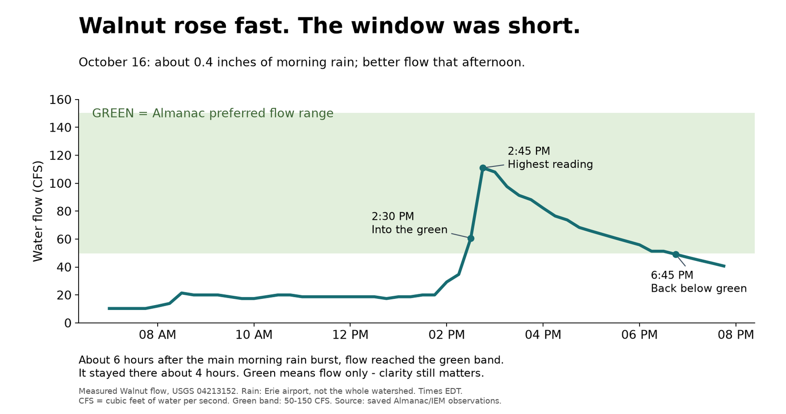
Erie airport recorded about four-tenths of an inch before the afternoon rise. Walnut reached the green band about six hours after the main morning rain burst. The full day's airport total was 0.47 inches.
That is encouraging, but it is not a recipe that says "add rain, wait six hours, catch steelhead." Where the rain lands, ground conditions and water clarity can change the result. Showers continued later that October day; the six hours were not measured from the end of the whole storm.
Where the weekend looks promising
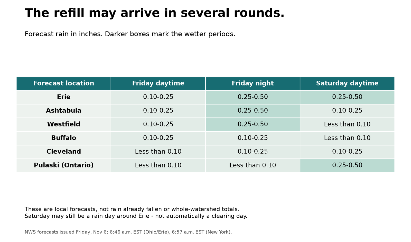
Pennsylvania: Walnut, nearby Elk and Crooked, and the eastern creeks such as Sixteenmile and Twentymile remain worth watching if rain reaches their basins. With more rain forecast Saturday around Erie, a rise could last longer or arrive in rounds. Elk's displayed flow is estimated from Walnut; it cannot independently prove what Elk is doing.
New York's Lake Erie shore: Westfield's wetter Friday-night forecast makes Chautauqua worth watching; check local rainfall before extending that outlook to Canadaway. Buffalo's today-and-tonight total is lighter, at 0.20-0.50 inches. Cattaraugus needs its own gauge-and-clarity check. Walnut's quick turnaround is not a clock for the Catt.
Ohio: Ashtabula's forecast has increased, especially tonight. That strengthens the reason to watch the eastern Ohio tributaries, including Ashtabula and Conneaut, while checking where the rain actually lands. Cleveland is lighter today, with more possible tonight and Saturday. Rocky, Chagrin and Ohio Grand still need their own rainfall and gauge checks; one forecast point does not cover their whole basins.
Lake Ontario: Around Pulaski, Saturday carries the stronger rain signal: a quarter to half an inch during the day. That is a separate timetable from Lake Erie. Check local conditions and controlled releases before making a Salmon River plan.
Thursday's water was already changing
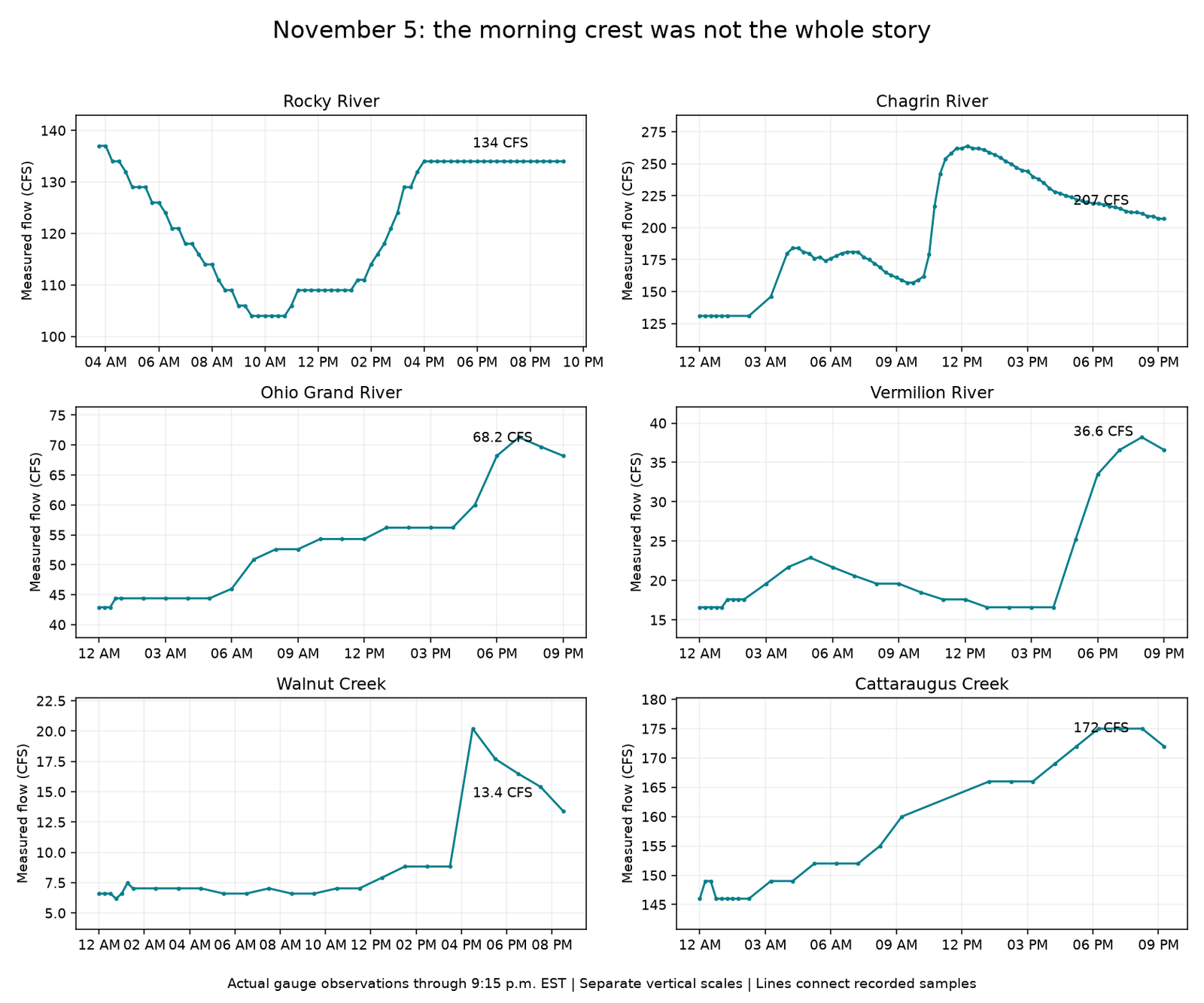
Later Thursday readings showed Chagrin easing from 235 to 207 CFS, Walnut from 20.2 to 13.4, Ohio Grand from 71.3 to 68.2, and Vermilion from 38.2 to 36.6. Rocky held near 134 in that reviewed window. These are afternoon/evening comparisons, not claimed peaks for the whole day.
The weekend plan
Friday: Watch where the rain lands and which creeks respond. Saturday: Be ready for more rain and another rise, especially around Erie; fish a clearing window only if one develops. Later in the weekend: Follow the falling water and improving clarity rather than promising yourself a particular morning. Small creeks may offer a short window; other waters may need longer.
There is hope for a useful weekend window. Better water can help fish move, but we have not confirmed a fresh run from this forecast. Bring the optimism. Let the creek handle the evidence.
Check the Explorer map and Walnut's latest reading before leaving.
Sources: saved USGS observations; Erie airport rain archived by Iowa Environmental Mesonet; NWS forecasts for Erie, Cleveland, Ashtabula, Westfield, Buffalo and Pulaski. Forecast basis: Friday, November 6, NWS updates at 6:46 and 6:57 a.m. EST. Thursday flow readings are historical context, not current Friday measurements. October times are EDT; November observations are EST. Airport rain is not a watershed-wide total. Conditions outlook, not newly verified catch reports.
